
- NEWS & CHASE DIARY -


- PREVIOUS CHASE YEAR DIARIES -


ARTICLE (April 13, 2013) - More Cameras for Sask. Highway Hotline
* When I am out Live Streaming, it will Broadcast live directly to the site & both my Twitter and my Facebook page.
* All my Videos can be found on my YOU TUBE channel.
- CURRENT CHASE YEAR DIARY -

I am absolutely HONORED to have 14 shiny METAL PRINTS hanging up at the entrance in HAAS NISSAN here in Yorkton !!!
Mon. July 31
Severe Warned Storms between Sintaluta - Melville SK Canada
Yet another frustrating chase day that ended up paying off at the end!
Started the day sitting around Whitewood as I was worried the storms were going to fire more South than my target (which was Grenfell).
Waited, and waited and waited .... Towers would bloom and die, rinse and repeat!
As I waited, there was a beautiful storm forming around the Raymore region.
Eventually, around 5 pm, a storm finally began to form near Zehner (just NE of Regina).
And away I went towards Sintaluta as it was heading in that SE direction.
It was looking not bad too! Wasn’t a big storm but had a nice base forming and it was still young.
By about 6:30 pm, it never really got going as it was struggling to develop and grow larger. The storm was totally dead.
At that point I seen that the storm that was originally near Raymore (which was moving North) and now taken a right hand turn and was basically now moving SE.
I blasted North. By about 7:30 pm I could see the storm in all it’s beauty near Lemburg.
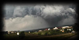
From there, I headed towards Duff and caught a stunning Supercell Storm that put on a great show!
I timelapsed it for some time before it finally began to get weaker and slowly fall apart around 8:30 pm.
Turned out to be a pretty cool chase day!
A few PHOTOS of the day:
Photo 1 |
Photo 2 |
Photo 3 |
Photo 4
HIGHLIGHT VIDEO
Tues. July 18
Severe Warned Storms between Ebenezer - Wroxton SK Canada
This day was yet another challenge and a day with many Wall Clouds!
I was seeing 2 different storm system. One towards the SE SK (Moosomin area and East). And another coming from Saskatoon towards Yorkton anytime after 4-5pm. I had to work, so went for the local option.
I was also worried that the cold air or smoke will kill severe potential or the CAP would win.
For the most part, the storms lined up to the models very well.
Some of the storms I was at, was hazy, assuming on the account of smoke in the atmosphere.
The day started off much cooler than a usual storm chase day and by noon it was only +15c. That also had me a little worried.
Got the day time heating around 2:30pm and then by 4pm the storms in the area I was watching began. I started right off the bat with a Suspicious lowering South of Ebenezer SK looking East around 4:25pm.
By about 5:20pm, I was on a fairly beefy looking Wall Cloud SE of Rhein that gave fairly close to producing a Tornado, but failed.
This part of the storm dropped lots of rain and hail.
After this, I was on another short lived Wall Cloud right beside Stornoway looking towards the East, followed by another one East a little further.
I followed the same system to the NE of Wroxton where I finally called it quits as it was flying at this point, heading to the Togo area and East, and I was unable to catch up. That, and there just was zero structure on it anymore.
A few PHOTOS of the day:
Photo 1 |
Photo 2 |
Photo 3 |
Photo 4 |
Photo 5 |
Photo 6 |
Photo 7
HIGHLIGHT VIDEO
Sat. July 1
Storms between Churchbridge - Rhein SK Canada
This ... was a frustrating chase day.
For targets, I was seeing 3 separate storm systems. Saskatoon to North Battleford, South of Swift Current and finally one somewhere potentially around the Yorkton Parkland region.
The Storms to the West "DID" have a better chance at becoming more severe and possibly even putting down a Tornado or 2 but sometimes (perhaps too often haha) I like to challenge myself and not go for the correct/big setup but find the next one.
I also felt like the CAP was going to win today .... For the most part it did. All the storms fell short, that is until about 7pm. Around that time, the storms near North Battleford and around Watrus finally began to intensify and develop structure.
I was not on those storms.
The storms I were on had the potential and tried .... they tried sooo hard, but just couldn't get the lift they needed!
I had a great looking cell on radar (but not as good visually) right at the start, near Churchbridge that I core punched to get to the South East side. Shortly after, fell apart.
From there, blasted North to Wroxton to catch the next cell of many that grew and died haha.
I headed West to see it's base and then as it began to fall apart, I decided to head North again towards Veregin where it also fell apart.
From there blasted West again as the storm was trying to gain some strength.
It died and I went home lol.
I tried!
Going home is probably what helped the other storms form haha, just kidding of course, sort of ;)
A few PHOTOS of the day:
Photo 1 |
Photo 2 |
Photo 3
? HIGHLIGHT VIDEO COMING SOON ?
Mon. June 26
Severe Warned Storms between Waldron - Yorkton SK Canada
I guess one can call this an "Old Fashioned" Local Chase Day haha.
I didn't touch my laptop, No live stream, didn't even record a second of video but I did have it packed in case something big happened.
Was just me, my camera, radar and the road.
I wasn't really certain the day was going to produce to much for storm structure potential.
I had forecasted the storms were going to be from pretty much the Big Muddy to North of Yorkton in mostly a "wet mess."
That is pretty much what happened.
Around 6:30 pm, some storm cells tried to toughen up but was all short lived.
The system I was on started to get going around 6:50pm. I got a nice little base. Had some good scud inflow and the base was even showing motion/brief mild rotation.
It didn't last long and fell apart to more of the wet mess.
There was a nice Shelf Cloud that formed later on around 8:30 pm around the Foam Lake area but I missed it.
Ended the day with a little bit of Mammatus Clouds over Yorkton.
A few PHOTOS of the day:
Photo 1 |
Photo 2 |
Photo 3 |
Photo 4
Mon. June 19
Severe/Tornado Warned Storms between Gladstone - Basswood MB Canada
LONG Chase Day !!!!
Left my house to go to my target of Minnedosa MB at 1 pm on June 19 and returned at 2:30 am June 20.
Overall the day “turned out” to be not too bad.
I was liking the chase day setup that models were suggesting but was worried that strong capping was going to win. That, and in Manitoba, I never have luck - like ever !!! Since 2013, perhaps only 3 storms were worth the drive haha!
This day, began to feel like one of those MANY days that didn’t. I waited, waited and waited.
Not much was happening and the stuff that did was all high based “garden showers” (aka trash).
Finally moved to Gladstone where the storms popping up had more potential.
Went after a little storm, trash. Another one, same thing - rinse and repeat.
Finally, seen a system moving NE towards Franklin so I booked off towards it as it was looking the best out of all the storms that were popping up.
8:30 pm (9:30 pm MB time) finally got a pretty little storm that actually had structure and some power to it! It even tried to produce a wall cloud.
It fell apart fast though as it was moving sooo fast!
From there (10 pm MB time), I noticed to the SW of me, by the towns of Moore Park & Forrest that there was a big juicy, angry looking cell on radar and was showing some rotation.
As it became Tornado Warned, I was trying to get South to get to the storm, but ran into some poor roads and limited road network. There were a couple grid roads that I tried but backed out as they were heavy waterlogged already and I had zero intentions of getting stuck in the middle of nowhere with a nasty storm moving overhead.
I stayed on it until about Neepawa and then eventually called it off and moved onto the next one, which happened to be to the West of me.
11:30 pm (MB time) I was back at Franklin literally in the middle of 2 Nasty storms. One was the one I left to my East and the new one moving towards me as it was passing Rapid City.
I core punched that storm (didn’t have much hail in it) and stayed with it till midnight, when I then abandoned that one to move to the NEW storm once again to my West.
The winds were pretty intense as I recorded over 88 km wind speeds on my Anemometer!
12:30 am (MB time) Messed with the angry storm near Basswood before calling it a day and heading back home.
A few PHOTOS of the day:
Photo 1 |
Photo 2 |
Photo 3 |
Photo 4 |
Photo 5
CHASE VIDEO
Fri. June 2
Storm over Yorkton SK Canada
Overall, it was some what of a frustrating day to forecast as models were not agreeing and I just wasn’t confident that there was enough Sheer and Daytime Heating. There was not.
I was seeing potential for storms in a few different places. Early afternoon around Weyburn to Assiniboia, Indian Head region and a possible isolated cell in the evening (5-6pm) around Calder.
The storm ingredients were better in the SW but I still wasn’t confident much was going to happen other than a wet mess (storms merging and just dropping rain with zero structure).
That is pretty much what happened.
Impatiently waiting, I took off and chased a couple smaller cells in hopes of glory (mostly around Willowbrook). I failed as the storms sucked lol.
Called it a day and went home.
Once home, around 5:45 pm, low and behold a storm began forming around Calder and moving West towards Yorkton.
I waited near the Yorkdale School of the beautiful FAST moving Shelf Cloud approaching Yorkton from the East moving West at 6:50 pm.
I got a few shots and did a little timelapse of the shelf cloud coming in, before it dropped about a inch of rain.
A few PHOTOS of the day:
Photo 1 |
Photo 2 |
Photo 3 |
Photo 4 |
TIMELAPSE VIDEO
Sat. May 27
Tornado Producing Storm SE of Regina SK Canada
The biggest storm potential was Weyburn to Assiniboia area. Storms DID fire there but were lacking ingredients to really get going.
I did see this day as a "potential" chase day but was fairly confident that those storms were not going to do much with what they were lacking. And on top of that, is a good 3-4 hr drive one way, so I figured I would save my gas for a better day.
The Storm in that area didn't do too much so I waa glad I never left the house ... BUT ... A pulse storm DID fire up SE of Regina and looked pretty decent on Radar so my good Storm Chasing friend Craig Boehm was near by so off he went.
Very shortly after he headed out, he messaged me he had a Wall Cloud and then shortly after that - Tornado!
Unfortunately a farm did get hit by this tornado south of regina and did sustain some damage. No injuries though.
A few PHOTOS of the day:
Photo 1 |
Photo 2 |
Photo 3 - Tornado Damage

just a reminder that anyone can watch my Live Stream through ...
Severe Studios.com
Direct stream (full page) - LINK
or
Zoom Radar
WATCH on your Mobile Devices with these Apps (both on Andriod & Itunes and are FREE):
ZOOM RADAR STORM CHASERS:
Android |
iTunes
MYRADAR Weather Radar:
Android |
iTunes