
2014 CHASE DIARY


ARTICLE (April 13) - More Cameras for Sask. Highway Hotline
* When I am out Live Streaming, it will Broadcast live directly to the site & both my Twitter and my Personal Facebook page.
(NOTE: If you are not a "Facebook Friend" you can still view to by clicking "Follow")
* All my Videos can be found on my YOU TUBE channel.
*Check out YORKTON THIS WEEK Newspaper for my weekly STORM PHOTO & WEATHER FACT OF THE WEEK - All Storm Season Long!
Tues. Aug. 5
Storm Hunting near Ogema Sk.
The area was put on Severe Thunderstorm Watch. My team and I headed out - wasn't an intense day but caught a beautful Shelf Cloud.
Photo 1 |
Photo 2 |
Photo 3 |
Photo 4 |
Photo 5 |
Mon. Aug. 4
Storm Hunting from Yorkton Sk - Lake of the Prairies Mb
The region between Yorkton Sk to Dauphin Mb were put on Severe Thunderstorm Watch. I headed out as not a lot ended up happening, but got some beautuful photos and a great Lightning shot via screencapture from Video.
Photo 1 |
Photo 2 |
Photo 3 |
Photo 4 |
Photo 5 |
Photo 6 |
Photo 7 |
Photo 8 |
Photo 9
Thurs. July 24
Torando Warned Storm around Assiniboia Sk. from within the DOMINATOR 3
A powerful Squall Line began to form on radar, and we were in great position. A large portion of the province fell under a severe thunderstorm risk. Large hail, lightning, strong winds and heavy downpours are the largest risks associated with these storms, and some places got hit with a lot!
We collected some great structure shots of right in front of the storm and then went into the beast. You can see from the highlight video that it was 0 visibility for a time period. Overall, fun and interesting day!
Live streamed as "Yorkton Storm Hunter" on TVNweather.com from within the Dominator 3.
A few PHOTOS of the day:
Photo 1 |
Photo 2 |
Photo 3 |
Photo 4 |
Photo 5 |
Photo 6 |
Photo 7 |
Photo 8 |
Photo 9 |
Photo 10
Photo 11 |
Photo 12 |
Photo 13 |
Photo 14 |
Photo 15 |
Photo 16 |
Photo 17 |
Photo 18 |
Photo 19 |
Photo 20
HIGHLIGHT VIDEO
Wed. July 23
Severe Warned Storm around Consul Sk. from within the DOMINATOR 3
The "now" iconic Saskatchewan Storm simply known as "Consul"
At one point we had an intense Super Cell dropping tons of rain and Baseball sized hail and a possible rain wrapped tornado (was never confirmed) !!!
This was a pretty wild and awesome chase that started off as a waiting game at Maple Creek. As the storm began to fire up, we headed South, right to it. This day was filled with wonderful Supercell Storm Structures, 120 km winds, intense rain, Baseball sized Hail and a possible Rain Wrapped Funnel Cloud (or Tornado - could not confirm)! The RFD cut was so sharp you could see blue sky through it - pretty spectacular to see !!
Live streamed as "Yorkton Storm Hunter" on TVNweather.com from within the Dominator 3.
Braydon Morisseau was in great position of the Funnel Cloud when he caught his Photo
He was in a better position for the shot than I was. I was across from the sunset.
A few PHOTOS of the day:
Photo 1 |
Photo 2 |
Photo 3 |
Photo 4 |
Photo 5 |
Photo 6 |
Photo 7 |
Photo 8 |
Photo 9 |
Photo 10 |
Photo 11 |
Photo 12
Photo 13 |
Photo 14 |
Photo 15 |
Photo 16 |
Photo 17 |
Photo 18 |
Photo 19 |
Photo 20 |
Photo 21 |
Photo 22 |
Photo 23
Photo 24 |
Photo 25 |
Photo 26 |
Photo 27 |
Photo 28 |
HIGHLIGHT VIDEO
Sat. July 5
Storm System near Ituna Sk. w/ Quarter Sized Hail
There was a TON of action in Sakatchewan this day - I had to work so I was "Late to the Game." There were 6 Tornadoes in Sask. this day, my team and I headed to the closest Storm Cell that we could make it to, being right around Ituna Sk.
We didn't end up with a lot bit got a beautiful Shelf Cloud (which I madea nice little Video Time-Lapse from) and then plowed by Quarter Sized Hail.
A few PHOTOS of the day:
Photo 1 |
Photo 2 |
Photo 3 |
Photo 4 |
Photo 5 |
Photo 6 |
Photo 7 |
Photo 8 |
HIGHLIGHT VIDEO
Sun. June 29
The 2014 Prairie Flood
The very slow moving storm system began to hit the Yorkton - Melville - Churchbridge (etc) areas Saturday afternoon with powerful winds and lots ... and lots ... of rain.
By the time I got out of my house at 5am on Sunday morning, my street was totally flooded and water was going into my basement. 2+ feet of water in my backyard, and at this moment didn't know how bad the rest of the communities were = pretty bad :(
I eventually had the things I needed to move to a "dry" spot in the basement, then I headed out with the Storm-Finder to see how all the other towns/communities were doing.
I began by heading East from Yorkton to Wroxton where I seen water near the highway at a lot of different approaches. From there went South towards Churchbridge where they looked pretty hard hit! Water was over the roads, side approaches washed out - water flowing over the train tracks. There were even some houses where the water has risen up and past the basements.
From there I headed back to Yorkton to continue to clean up my basement.
Environment Canada rainfall totals from Friday to 3:34 PM today. (this is just SOME of the areas that were hit)
Moosomin.... 200 mm (unofficial)
Redvers.... 175 mm (unofficial)
Broadview.... ~150 mm
Melville.... 128 mm
Yorkton.... 120 mm
Regina.... 97 mm
Indian Head.... 87 mm
Hudson Bay.... 77 mm
Nipawin.... 60 mm
Melfort.... 60 mm
Wynyard.... 49 mm
Estevan.... 43 mm
Weyburn.... 41 mm
Detailed report from GLOBAL NEWS - REGINA
SOME SASK FLOOD FACTS:
- 68 Communities were declared State of Emergency
- 78 Roads and Bridges Closed - some due to washing away
- 300+ people evacuated in Sask.
A few PHOTOS of the day:
Photo 1 - my street Sunday am |
Photo 2 | - Car Dealership in Yorkton |
Photo 3 |
Photos between Wroxton & Churchbridge:
Photo 4 |
Photo 5 |
Photo 6 |
Photo 7 |
Photo 8 |
Photo 9 |
Photo 10 |
Photo 11 |
Photo 12 |
Photo 13
Photo 14 - HWY between Yorkton & Melville
CROOKED LAKE SK.
I was out viewing the Storm Damage at Crooked Lake with the The Weather Network team of Deb Matejicka & Shawn Legg
Photo 15 |
Photo 16 |
Photo 17 |
Photo 18 |
Photo 19 |
Photo 20 |
Photo 21 |
Photo 22 |
Photo 23 |
Photo 24
VIDEOS OF THE DAMAGE
VIDEO of My Street
Footage from TVN Weather member Sean Schofer driving between Yorkton and Melville
More Footage from Sean Schofer- flooding in Melville
Footage of the flooding near Churchbridge when we were out checking out the areas on Sunday. Taken by William Stadnichuk
Fri. June 27
Severe Warned Storm System from Moosimin SK - Virden MB
The Storm began a little later in the afternoon, and we were in good position - left early enough that when we had to change from one town to the next, we were still good for time.
Overall, it was a short lived system as most of it began to die as it blew North towards us from North Dakota. We did however, manage to catch 3 Funnel Clouds. The one in Virden MB stayed active for a good minute or two. The 3rd one was gone as fast as it came.
A few PHOTOS of the day:
Photo 1 |
Photo 2 |
Photo 3 |
Photo 4 |
Photo 5
HIGHLIGHT VIDEO
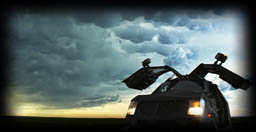
Sat. June 21
!!! NEW STORM HUNTING VEHICLE - REVEALED !!!

Photo 1 |
Photo 2
Special Thanks to HAAS NISSAN (in Yorkton) for the Sponsorship!! and to Auto-Trim Signs for the awesome Decal work!!
Mon. June 9
Severe Warned Storm System from Regina - Rockglen
The Storm Syetem began to look a little better shortly after we past Regina and continued West. Overall, the storm wasn't too powerful of a system, but it did produce some powerful and damaging winds around Assiniboia along with some heavy but short lived hail.
The storm concluded with a stunning sunset :)
A few PHOTOS of the day:
Photo 1 |
Photo 2 |
Photo 3 |
Photo 4 |
Photo 5
Sat. May 24
STORM HUNTING in the USA
I went to the USA and Storm Hunted with fellow Canadian, Notanee Bourassa.
He Lives Streams on TVNweather.com as "RAIDEN"
Follow him on TWITTER
T E X A S
Big Spring - Garden City (May 26)
Landed in Oklahoma City and headed straight for Texas to get into position for the storm in Big Spring Texas on may 26.
It was a great first chase day in the states as we heard Tornado Sirens, and seen dozens and dozens on Storm Chasers/Spotters as well as Media, including Canada's Own Weather Network Team of Mark Robinson & Jaclyn Whittal (she took the photo - that is Notanee & Myself with her).
A few PHOTOS of the day:
Photo 1 |
Photo 2 |
Photo 3 |
Photo 4 |
Photo 5 |
Photo 6 |
Photo 7 |
Photo 8 |
Photo 9 |
Photo 10 |
Photo 11 |
Photo 12 |
Photo 13
Photo 14 |
Photo 15 |
Photo 16 |
Photo 17 |
Photo 18 |
Photo 19 |
Photo 20 |
Photo 21 |
Photo 22 |
Photo 23 |
Photo 24 |
Photo 25
HIGHLIGHT VIDEO
M O N T A N A
Miles City - Harve (May 28)
My original statement for Montana was .. . Tomorrow in Montana could be the "Gold Mine" of the 2014 Chase Season... Notanee and I will be right in the heart of it, streaming Live on TVNweather.com as "RAIDEN" (if data allows)
I was glad I said that :)
Montata - Was - Awesome!! Our chase was all between Miles City and Havre. As we stopped for a quick bite to eat thinking we had "some time" before the storm. I noticed that it quickly was getting dark outside. We devoured our food and ventured off towards the storm. The "start" of the storm was showing a chance for 2 inch or even larger hail so we agreed to stay in front the best we could. The storm grew larger and larger and merged into a beautiful BEAST! With a monster Shelf Cloud tailing us, at one point all the cows were moo-ing in panic and we could hear a roar. I could see ground debris. After consulting with others who had radar correlation. I believe it may of beeen a tornado. I did see straight line winds AHEAD of this so this was a separate event. Maybe gustnado at very minimum. Never the less, the storm was Powerful, Beautiful and Intense !!!
We Lived Streamed on TVNweather.com as "RAIDEN"
"RAIDEN" is Notanee Bourassa
Follow him on Facebook
Twitter
A few PHOTOS of the day:
Photo 1 |
Photo 2 |
Photo 3 |
Photo 4 |
Photo 5 |
Photo 6 |
Photo 7 |
Photo 8 |
Photo 9
Photo 10 |
Photo 11 |
Photo 12 |
Photo 13 |
HIGHLIGHT VIDEO
Mon. May 12
!!! NEW STORM HUNTING VEHICLE !!!
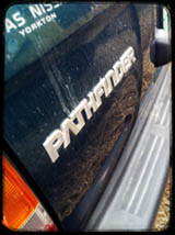
Special Thanks to HAAS NISSAN (in Yorkton) for the Sponsorship!!
Pathfinder currently being "Customized"
Tues. Feb. 18
NORTHERN LIGHTS
A few PHOTOS of the day:
Photo 1 |
Photo 2 |
Photo 3 |
Photo 4 |
Photo 5 |
Photo 6 |
Photo 7
Thurs. Jan. 26
BLOWING SNOW WARNING - YORKTON
A few PHOTOS of the day:
Photo 1 |
Photo 2
HIGHLIGHT VIDEO
Photo |