- NEWS & CHASE DIARY -


                              - PREVIOUS CHASE YEAR DIARIES -


ARTICLE (April 13, 2013) - More Cameras for Sask. Highway Hotline

* When I am out Live Streaming, it will Broadcast live directly to the site & both my Twitter and my Facebook page.


* All my Videos can be found on my YOU TUBE channel.


                                                                                              - CURRENT CHASE YEAR DIARY -


I am absolutely HONORED to have 14 shiny METAL PRINTS hanging up at the entrance in HAAS NISSAN here in Yorkton !!!
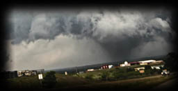


Thurs. July 10
Storms between Ceylon & Verwood SK Canada
For storms on this day, I was seeing the SW corner towards Assiniboia and East and also MB around Winnipeg moving East.
Models suggested that the storm will have a STRONG CAP and low CAPE values, so could just be non-severe storms, BUT severe is possible!
I went with the "possible."

Wildfire smoke also made it's return, so that very possibly weakened the storms also.

Overall, a little bit of a frustrating chase day as the storms (due to lacking CAPE and the CAP), just could not get organized. They got close a couple times, but that's about all.

I started the chase as the storms formed WAY earlier than models suggested (started around 2pm when models says 5-6pm) around Ceylon. I seen the storm getting close to Assiniboia as I was still on my drive to my target, so decided to follow it's storm direction of SE and try to meet up with it around Minton.
South of Minton, I could see the lower edge of the storm as it was pretty much touching the US border at this point, so kept blasting South.
Caught up to an interesting scene just a couple miles away from Regway US Border Crossing.

From there, I went through the very scenic drive of the Big Muddy and up towards Willow Bunch where I caught some cool storm structure (just to the North of the town).
After that, followed the system East towards Glasnevin where it all fell apart and the whole thing was just a wet mess, so called it a day.


A few PHOTOS of the day: - MORE TO COME ...
Photo 1 | Photo 2 |

CHASE VIDEO IN THE WORKS


Sun. July 6
Severe Warned Storm between Assiniboia & Bengough SK Canada
This was a tough day to forecast and a LONG driving day haha! (13.5 hours from leaving my home to arriving back at 2 am the next day)
I was seeing 2 main storms systems.
1. around the Gravelbourg region as it moves it way East and intensifies (for a time)
2. a long line of storms (perhaps part will be both severe and non-severe) crossing from Alberta into SK from basically Frontier (SW) all the way to Unity (and perhaps even more North).
The 1st system was my main interest for the start as models suggested it would makes it way East roughly between Regina, Rouleau, Weyburn.
As this storm eventually weakens, the 2nd system could split in the region South of Moose Jaw as it moves SE.

There was also Capping issues with this system that "could" prevent initiation or perhaps weaken the system.

My target for the potential 1st line of storms was Avonlea.
I got my gas and waited for a few radar runs. From there seen the 1st line of storms begin to form, but the cap was winning as they were all weak. I decided to go after the big system coming in from the Alberta border making it's way slowly East.
I ventured off towards Galilee and then down HWY 36 through Crane Valley and then decided to keep going, so made my way to Assiniboia.
Topped off my gas as I could see the long Squall Line like beast approaching!
It was starting to look quite nice so found a road just to the West of town with the Richardson Pioneer plant (which made for a great foreground), and there I sat and watched it arrive with it's structural beauty.

From there I played Cat & Mouse with the storm.
That means, blast East to out of the rain, pull over, take a few pics, and blast East to get back out of the rain, rinse and repeat.

From there made my way to Verwood where I was seeing some rotation on radar via Velocity.
I Core Punched the storm to get to the South side and make my way to Willow Bunch.

From there I "attempted" to find a way to the storm between Bengough and Minto (to my SE) as it was starting to show a lot of rotation!

Along the way between Willow Bunch and Harptree, and now on the back side of the whole storm system, 1st witnessed an intense and beautiful bright rainbow followed by some Thick, Colorful & Girthy storm structure!!!

From there, continued on towards Bengough on a poorly chosen road which was VERY waterlogged, slippery and squishy and almost nailed a deer!
The road was just too much, and after slipping and sliding at 50 kms, I called it quits!

Fun Chase Day!


A few PHOTOS of the day: - MORE TO COME ...
Photo 1 | Photo 2 | Photo 3 |

CHASE VIDEO IN THE WORKS


Fri. June 27
Tornado/Severe Warned Storms between Russell, Silverton & Angusville MB Canada
My initial target on this day was in the region of Rocanville SK.

In the am, as models began to update, what 00z shows was totally different as 06z and so forth. I felt like North Dakota was going to have the strongest storm potential, but at the same time SK and MB will have "some" potential also.
There was also the worry that the USA storms could absorb our energy making ours not happen - that and there was a strong Cap in play (prevents storms from building).

Models were suggesting that storms were going to fire early and that the Tornado potential was going to be early also.
I made my way to Rocanville around 1pm and then sat and waited.
You could see the boundaries when looking at "Precipitation Depiction" on Radarscope, which was good as I was under it.
Sat some time longer ... and waited.

A few chasers suggested I was too far North and that the storms were going to be more towards Whitewood area.
After a bit, I did see via Satellite that there were clusters forming and also a boundary visible, so off I went ...
I was wrong lol.
Around 3:30 pm, pixels began to popup on Radarscope, aka the storms may be starting - and guess where ... just to the North of Rocanville (haha, yup) to the South East of Gerald. From where I was sitting, I could see the beautiful Anvil Cloud forming.
Off I went!

The chase started just to the South East of Russell MB as the cell near Inglis (just to my North) became Tornado Warned.
I went East, core-punched the storm and dropped South at Angisville to get to the South side of the system.
Got some cool structure and had a fair bit of rotation!
Seeing the clouds bend "upward" was different and pretty cool!

Around 6:15 pm (7:15 MB), I could see the storm forming near Marchwell SK as it was moving East towards me, and visually was beginning to look pretty nice!

By 6:30 (7:30 MB), I was near Silverton looking West in front of that storm system, which was "trying" to form Mothership Supercell storm structure!
It wasn't super strong and began to weaken after a bit.

As I sat there, the storm to my West began to merge with the storm to my East.
I was near a farmyard, by some grain bins, and it sure made for a very "Prairie Themed" photo!

As the storm began to merge, and the colors exploded, a big hailcore became visible and heading right towards me.
As it approached, I caught (for me) some of the coolest Hail Footage I have ever taken. Where I was sitting, it was bone dry but looking just down the road to my East I can hear and see the hail falling! It looked soo cool! I can see every single little ball flying straight down. Got some very footage of that moment!

The hailcore dropped toonie to ping pong ball sized hail.

From there, the storms began to die out so I made my way back home.
On my journey back, I caught up to a little storm cell near Saltcoats SK while the sunset was happening, and what a super pretty and stellar stormy sunset it became!

What a fun chase day!


A few PHOTOS of the day: - MORE TO COME ...
Photo 1 | Photo 2 | Photo 3 |

CHASE VIDEO IN THE WORKS


Thurs. June 26
Tornado Warned Storm between Briercrest & Weyburn SK Canada
This was a stellar chase day filled with adventure, 150 km winds (possible close range tornado) and beautiful storm structure!!!

I was forecasting that storms were going to go off somewhere between Crane Valley to Pangman, and boy was I close!
I started the chase around just South of Moose Jaw and then blasted East to Briercrest as the storm was forming near Cardross and I wanted to get East of it.

Storm started to look nice as I dropped South towards Milestone to be treated with my first Wall Cloud of the day (and some Mammatus Clouds).

4:30 pm, I was North of Pangman and East of Edgeworth looking at another lowering and the start of some nice storm structure with angry fingers!
The storm structure began to get better and better and I dropped to Pangman to fill up on gas.

By 5pm, the storm structure between Pangman and Ogema was the Next Level of Awesome!!!

by 5:20 pm was on some more nice Mothership style Structure as I made my way to Ceylon.

5:40 pm, I was in between Ceylon and Radville when things began to get INTENSE !!!
I had crazy strong rotation showing up literally right behind me (to my West, aka Ceylon direction) as my Anemometer was reading 150 km + winds !!!
I was outside of the truck taking a photo of an abandoned house with the storm in the background when this began and MAN OH MAN was the winds insane!!!

I began to run back to the truck. That is when the winds literally shoved me back a good foot or more! (my cowboy boots literally make a streak in the gravel). This moment was and felt like when you see people in a Hurricane walking and the wind is blowing them back - that is EXACTLY what was happening!

To get back into my truck, I had to pull with both arms and use a foot on the truck for extra leverage! Got in the truck and then filmed the insane rotation (possible close range Tornado) for a few moments - then knew I had to get the HELL out of there !

I blasted East down the grid a little further, just to be safe and not dissolve in whatever that beast was!

By 6pm, I made it to Radville and was finally on the ledge of this BEAST of a storm system where I could once again see some storm structure and it was becoming a Big Wet Mess Shelf Cloud at this point.

From there headed North towards Weyburn, keeping with the storm structure to my West.

Made it to Weyburn around 7pm. Weyburn was hit hard with heavy rain and had localized flooding.

What a great chase day!


A few PHOTOS of the day: - MORE TO COME ...
Photo 1 - MONSTER Storm | Photo 2 - Possible TORNADO (the moment with 150+ kms winds)
Photo 3 | Photo 4

CHASE VIDEO


Sat. June 19
Tornado/Severe Warned Storms between Grenfell - Sintaluta - Melville SK Canada
This particular storm produced 2 Tornadoes. This as the main Tornado but also a brief Satellite Tornado to the right side of it (North side), both which I caught. (One was rated an EF-2)

I did 2 things on this storm that were on my "Storm Chasing Bucket List" that I have never actually done before ...
1. record the entire tornado starting from Wall Cloud, to funnel to tornado to end.
2. Sunlit background of a tornado!

Pretty proud of that !!!

This was a unique chase day! Days before, models were all agreeing but as it got closer to that am, things began to disagree with one another and create mental chaser frustration haha.

My initial target was Qu'Appelle to Grenfell and down the #1 HWY with hail and tornadoes very likely.
I arrived at Indian Head around 1pm as models were suggesting storms could fire early.
There were chasers all over the area on this day which does not happen a lot in Sask haha (many to the West of me, roughly Whitewood area).

I sat and sat and sat.

Storms began to form at the US Border around Weyburn and Radville but nothing for me.

Waited some more .... growing impatient as the storms to the South by Radville got stronger, but were roughly heading my way.

Waited some more .... and then said screw it and began to blast South just a little to try to observe.

I caught up to the one South of Wolseley as it was heading East through Peeples.
It wasn't looking that great so began to look at my options some more.

There were storms South of me by Oxbow at this point but that WAY out of my reach for time (2+ hrs) and a cell that was growing just to the West of Regina. I chose that and off I went, back to my initial target area of Indian Head (roughly 4:30 pm).

As I got to Sintaluta, I seen a very fast forming funnel cloud so dropped on the 1st grid road to the South I could see. Within seconds, had a Beautiful Tornado !!!!

I filmed it for 17 mins.
It was rated as an EF-2.

After that, I stayed with the storm at the same spot as I had another funnel and Wall Cloud and then a few mins later, yet another one. I stayed on the system till it's death.

Around this time, learnt that the Oxbow storm also dropped a Tornado.

From there, for the most part all these storm were dying off while a Storm to the North West of my by Wynard was beginning to get stronger.

I headed home, but was still observing that storm as it was moving East sort of towards where I was going.

Once I hit Melville (around 8:30 pm), I blasted North and West a little (to the East of Fenwood) to begin chasing this storm which also became Tornado Warned. I stayed with the storm system till about 10 pm before calling it a day.

4 Confirmed Tornadoes on this day, 4 more being investigated bringing to possible total to 8!

Great Chase Day!


A few PHOTOS of the day:
Photo 1 - TORNADO | Photo 2 - TORNADO | Photo 3

CHASE VIDEO


Sat. June 14
Severe Warned Storm between Craik, Liberty & Chamberlain SK Canada
For this day, I had 2 targets but seen potential in about 4 areas.
My main 2 were Chamberlain and Imperial. I seen additional potential in the Pangman region as well as Humbolt area and more North.

For the most part, that is pretty much exactly what happened, but the North storms (aka North of Saskatoon, Humbolt, etc) were the ones that got the strength to them, even produced a Tornado and some nice storm structure (along with some welcoming rain to assist with the wildfires).

I made it to Imperial area around 3pm as expected. My storm was a little more to the SW then I anticipated (which happens), so I went a little more South.

Near Penzance (looking West), seen a possible Wall Cloud that was looking quite nice for a little bit, but over time got taken over by all the rain and everything turned into a wet mess.

From there, tried to see if anything had potential as I made my way to Chamberlain to try to see if I can see the system that was passing Stony Beach.

It wasn’t all that exciting anymore at that point, so called it a day.


A few PHOTOS of the day:
Photo 1

CHASE VIDEO


WILDFIRES IN MAY
Most of the month of May and into June has been rough with the battle of Saskatchewan, Manitoba and Alberta Wildfires. Here are some posts that I've made covering the issues.

Wildfire Smoke Map
Smoke from within Yorkton
Smoke Plume Map
Map showing Active Fires (at that current time)


Mon. May 12
Tornado Warned Storm to the West of Yorkton SK Canada.
I unfortunately had to work (such is life haha), but got to watch the Tornado Warned storm pass by to the West of Yorkton from a Parking Lot. After this, it continued to move NE towards Kamsack and then into MB.

I could be wrong but this might be the 1st Tornado Warned system in Western Canada this year, glad to be a small part of it haha!

PHOTO from the day:
Photo 1
Josh Gogal got some FANTASTIC shots of this storm as it moved NE. Check them out HERE.


just a reminder that anyone can watch my Live Stream through ...
Severe Studios.com

Direct stream (full page) - LINK
WATCH on your Mobile Devices with these Apps (on Andriod & Itunes and are FREE):

MYRADAR Weather Radar:
Android | iTunes