
2019 CHASE DIARY


* When I am out Live Streaming, it will Broadcast live directly to the site & both my Twitter and my Facebook page.
* All my Videos can be found on my YOU TUBE channel.
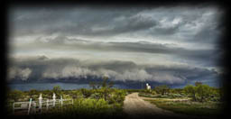
Sat. Aug 3
Severe Warned Storm between Springside - Willowbrook - Yorkton SK
This was one of those days I was not really planning of chasing as models looked "meh" at best.
In the evening, as the storm began to form, and strengthen - I changed my mind and headed out to catch some beautiful storm structure.
PHOTO of the day:
Photo 1 |
Photo 2 |
Photo 3 |
Wed. July 24
Thunderstorm around Ituna SK
Non Severe Thunderstorm near Ituna SK Canada around 4:30 pm
PHOTO of the day:
Photo 1
Thurs. July 18
Thunderstorm over Yorkton SK
Short lived and fast moving Thunderstorm moving North East towards Yorkton SK, facing North around 8:00pm
PHOTO of the day:
Photo 1 |
Photo 2 |
Photo 3 |
Photo 4
Sat. July 13
Severe Warned Thunderstorm 15 miles South of Melville SK
Late into the evening, I finally got free from a previous engagement and headed out late at night to see what I can catch. Caught up to a beautiful thunderstorm around 11:50 pm
PHOTO of the day:
Photo 1 |
Photo 2 |
Photo 3 |
Thurs. July 11
Thunderstorm around Carlyle SK
With the Storm-Finder (my truck) still in the shop ... for the 1st time in 5 Years, the Storm Car is out of "Storm Chasing" retirement!
Storm wise, it was not that special as it didn't really form.
PHOTO of the day:
Photo 1
Mon. July 8
Severe Warned Storm from Theodore - Wroxton SK
With my truck still in the shop getting repaired, my Dad came and picked me up for a local storm chase!
A nice Cell was forming between Sheho and Theodore so away we went!
Just West of Theodore we got in front of the storm as it began to really wrap up and intensify! Structure began to take shape and even a Wall Cloud formed!
After that we followed the storm to Rhein and finally stopped at Wroxton!
Fun chase day!
A few PHOTOS of the day: - MORE TO COME
Photo 1 |
Photo 2 |
Photo 3 |
Photo 4 |
Photo 5 |
Photo 6
HIGHLIGHT VIDEO
Sun. July 7
Tornado Warned Storm 10 km North of Gravelbourg SK
One would look at the Beautiful and intense storm photo I took and be all excited.... But on this day, that was not the case for me :-(
Something (possibly electrical) failed in my truck (aka The Storm-Finder) as I pulled over to talk to someone.... And it just shut off.
Was sort of a bad time also as we had this storm moving over as well as a Wall Cloud to our East and another to our South!
Luckily photography friend and yesterday, life saver was near by and assisted me. We couldn't get the truck boosted so started to call tow trucks....... 7. After calling 7, one from Gravelbourg called back.... Gravelbourg Auto Body & Towing Service , came to the rescue!!!!
He came, towed it to his shop and we charged the battery. If I was to stop it would die again, so for me, the chase was done, even though I was still very close to the Tornado Warned Storm system. I had to go home. No stops, just straight home.
Not going to lie, that was really tough. I know you all know that I love severe weather, but the passion runs DEEP through my veins, I totally had to fight back a tear or two while driving past the storm.
Storm Chasing "IS" my life, it means so much to me! Leaving that storm, broke my heart a little :(
And not only that, seeing my truck get towed, to me was like watching a very close friend get put on a stretcher and taken away by ambulance. I spend hundreds of hours in that truck going from storm to storm and down long lonely highways, it was truly sad to watch that event take place.
I ended up making it home safely. With all this, I can also say that the truck is going to be in good hands at Haas Nissan as they try to figure out what's wrong, but with that comes for the first time in 5 years...... The return of my Storm Car!
One final thing I want to mention is that you all should give Ed Fonger's Facebook page a follow...
Time Bandit Photography by Ed Fonger
This man, he stayed with me the entire time, also missing the storm just to make sure that I was safe.
Dude, you are too awesome!
I can never say Thank You enough times for your help!
Anyways, that was my day!
A few PHOTOS of the day: - MORE TO COME
Photo 1 |
HIGHLIGHT VIDEO - IN THE WORKS
Mon. July 1
Storm incoming towards Yorkton SK
At roughly 8:30 pm, I was West of Otthon. watching and waiting for the storm to come to me!
This storm was part of a much larger Squall Line storm system that dropped 2 Tornadoes earlier in the evening!
1st one was 30 miles south of Moose Jaw and the 2nd was just north of Avonlea .
Both were caught by Skstormchaser Photography by Craig Boehm
A few PHOTOS of the day: - MORE TO COME
Photo 1 |
HIGHLIGHT VIDEO
Wed. June 29
Storm South of Whitewood SK around 6 pm
Overall, I was NOT convinced that the day was going to be any good.
The Convective and Surface Models were showing everything fantastic and potentially dangerous for possible tornadoes (almosty too good to be true) but the Precipitation models were showing very different.
I ended up chasing as a few other chasers talked me into going lol but I was expecting a bust as I was seeing all the action staying South of the Border into North Dakota, which is what happened.
My target was originally for Redverse SK to Pipestone MB. As I left the house and began the drive down South, I pulled over at Carlyle and said .... nope.
I caught a little storm at the start around Whitewood but there wasn’t much to it so kept going.
I then noticed on radar the one storm coming across the US Border between Estevan and Oxbow looked really nice. So I headed down.
As I got close, it fell apart and fast! So I said screw it, I am going home haha!
As heading back, I noticed some storms forming South of Whitewood, so I went for it!
It turned out to be a rather beautiful little storm and I even got to see some rare Kelvin Helmhomtz clouds (clouds with "fins" on the top of them)!
A few PHOTOS of the day:
Photo 1 |
Photo 2 |
Photo 3 |
Photo 4 |
HIGHLIGHT VIDEO - IN THE WORKS
Fri. June 28
Severe Warned Storm East of Assiniboia SK
I wasn't overly sure how this day's forecast was going to pan out. Many models were disagreeing with each other.
Finally settled on one of two spots - Moose Jaw or Weyburn. I went for Weyburn.
Both were wrong as the storms fired much East from what all models were suggesting.
I made my way about 10 kms East of Assiniboia to see some beautiful structure beginning to form!
The system began to form into a beast and was ramping up strong! Storm structure, rain free and had a Wall Cloud!
Sat with it until almost the end and it then pushed it's way North East.
Great Chase Day!
A few PHOTOS of the day: -
Photo 1 |
Photo 2 |
Photo 3 |
Photo 4 |
Photo 5 |
Photo 6 |
Photo 7 |
Photo 8 |
Photo 9 |
Photo 10
HIGHLIGHT VIDEO - IN THE WORKS
Fri. June 14
Storms between Roche Percee - Stoughton SK
Overall, it was a tough chase day! The storms tried to match where the models were suggesting but with the lack of ingredients like moisture, the storms just didn't bloom!
I started off the day setting up and watching the towers form in USA from a gas station in Estevan. I was watching and time lapsing the growing tower in Nooman, North Dakota trying to decide whether or not I should stay in Canada or head to the states.
I ended up staying and blowing North to the storms forming between Benson, Midale & Stoughton.
Near the end of the chase day - had a possible lowering or Wall Cloud on the West side of Stoughton so I was observing!
It was good to finally see some rain as the farmers have been needing it badly!
A few PHOTOS of the day: - MORE TO COME
Photo 1 |
HIGHLIGHT VIDEO - IN THE WORKS
Thurs. June 13
Storms between Cadillac - Assiniboia SK
The storm setup did not really pan out to what models were suggesting. They were showing there was a chance for severe cells to form, but as the day began and the 1st cell I was on was forming a nice base, shortly after it just fell apart.
The storms continued to do so over and over again through the day in the SW corner.
I finally called it quits and went to Assiniboia for supper. Ate and seen this absolutely beautiful storm rolling through with a sunset backdrop!
Followed it East to where the wild lightning began!
16 Hour chase day and 1200 kms!
Got home at 1:30 in the am lol
A few PHOTOS of the day: - MORE TO COME
Photo 1 |
Photo 2 |
Photo 3 |
Photo 4 |
Photo 5
HIGHLIGHT VIDEO
Sun. June 9
Non-Severe Storms from between Lafleche - Crichton SK.
Caught a beautiful scene at 5:15 pm as the storm was attempting to strengthen a couple miles West of Crichton SK, next to that it was not overly an active chase day.
A few PHOTOS of the day: - MORE TO COME
Photo 1 |
Photo 2
Sun. May 5 - Fri. May 17
STORM HUNTING in the USA
I headed to the USA and Solo Storm Hunted for my 1st time!
Traveled 11,000 kms in 15 days!
Pretty Incredible that 15 days in Tornado Alley (minus 2 days were just driving - 1 to enter USA and one to leave also one to get from Fort Stockton, Texas to the SW corner of Nebraska) that I had 9 great chase days!!!
So many great storms, moments and memories! I also got to meet some fantastic people along the way!
May 17, 2019
Tornado / Severe Warned Storms between Sedgwick, Colorado - North Platte, Nebraska
This day was intense! The models were suggesting various spots and many chasers chose many different spots and probably changed their target many times lol.
How I thought the day was going to go was that the cells would fire off around of a little West of Julesburg, Colorado and then explode between there and Ogallala, Nebraska. While that was happening there would also be action firing in Kansas/Nebraska border as well as South East of North Platte. I went South West into Colorado.
I had a fantastic day and was in some intense moments! Especially getting under a rotating meso, having insane winds and getting tennis ball sized Hail thrown at me! While that was happening, my Live Stream was also LIVE on The Weather Channel!
I also got to see some absolutely incredible storm structure and ended the chase with some insane lightning East of North Platte (near Maxwell).
The tornadoes fired up East of me, South of North Platte so I missed them, but that fine. That's all a part of the adventure, you can't get them all!
I have seen tornadoes before, this was the first time I've got to witness that type of supercell structure!!!!
A few PHOTOS of the day: - IN THE WORKS
Photo 1 |
Photo 2 |
Photo 3 |
Photo 4 |
Photo 5 |
Photo 6 |
Photo 7 |
Photo 8
HIGHLIGHT VIDEO - IN THE WORKS
May 16, 2019
Severe Warned Storm between Hammingford - Bridgeport, Nebraska
Overall I was not totally sure what to expect on this chase as models were not really agreeing with one another!
It ended up being a fun little chase. At first the storm had a fairly nice base and was beginning to get some decent structure! Got into the storm, but it just didnt want to really "bloom." As the storm structre would form, it would also begin to fall aprart!
A few PHOTOS of the day: - IN THE WORKS
Photo 1 |
Photo 2 |
Photo 3 |
Photo 4 |
Photo 5 |
Photo 6 |
Photo 7 |
Photo 8 |
Photo 9 |
Photo 10
HIGHLIGHT VIDEO - IN THE WORKS
May 15, 2019
Severe Warned Storm between Bird City, Kansas - Maywood Nebraska
I started the chase day with a possible Landspout Tornado (or perhaps a gustnado) while I was on hwy 161 in Kansas almost at the Nebraska border while heading North to Benkelman NE!
Ended up chasing to between Trenton and McCook Nebraska where I got some beautiful storm structure before pushing North of the storm while on the way to North Platte to catch some more incredible Mammatus Clouds and a powerful looking microburst along with a beautiful stormy sunset!
A few PHOTOS of the day: - IN THE WORKS
Photo 1 |
HIGHLIGHT VIDEO - IN THE WORKS
May 14, 2019
Storms between St. Francis - Bird City - Goodland, Kansas
This day I was more prepping up for the next couple of days.
After my long drive from Fort Stockton Texas to Goodland Kansas, I got a good night's rest, had a good breakfast, found a fantastic coffee shop and checked out a few local stores, killing some time until my storms began forming and off I went.
Nothing super intense on this chase, but did get some interesting storm structure that almost looked like an Octopus in the sky!
Ended the chase day with some beautiful Mammatus Clouds while sitting at my motel!
A few PHOTOS of the day: - IN THE WORKS
Photo 1 |
HIGHLIGHT VIDEO - IN THE WORKS
May 12, 2019
Severe Warned Storm between Fort Stockton - Fort Davis, Texas
Overall I was not totally sure what to expect as models were both great and disagreeing.
But, I was there on a Storm Chasing Adventure Holiday so I took every opportunity that I can get to chase severe weather!
This day didn't fully go "great" but I DID manage to see a wall cloud and some beautiful storm structure before everything became outflow dominant as they came over the Mountains in Mexico.
A few PHOTOS of the day: - IN THE WORKS
Photo 1 |
HIGHLIGHT VIDEO - IN THE WORKS
NEW MEXICO
White Sands National Monument (May 9)
I had a day off from storm chasing, so I decided to explore New Mexico while heading to White Sands National Monument.
Alright! Soo.... Out of the the past 3 out of 4 chases and then again on this day, I've quoted Star Wars : "I've got a bad feeling about this. "
This experience was a different bad feeling lol.
So my drive from point A to B (B being the White Sands National Monument, New Mexico) was 3.5 hours, that took me over 6 as I kept finding things along the way, aka Sight Seeing lol. (spent about 12 hours in total in the truck yesterday).
So fine, I get there and WOW what a place!!!
The White Sands National Monument is in the northern Chihuahuan Desert and is roughly 20 miles! To top it off it was +31 and insanely windy!
I drove to the end (about 8 miles in) parked the truck and went for a little walk.
Once you are about 30 feet away, you can no longer see your vehicle. There is also warning signs about getting lost very easily.
So fine, I do my thing, walk to the west taking photos etc. Got a sunset pic and then decided to head back.
And head back, and head back......
Then began to think to myself, I don't remember walking this far west.
I then head another direction.... Nothing.
And another.... Nothing.
After about 45 mins to an hour, frustration is honestly beginning to set in.
I even laughed to myself.... Well, I guess I'm sleeping in the desert tonight! LOL
So then I began to think....
OK..... I began to look at my early photos and try to match them with the mountain range in the background.
I then climbed one of the bigger sand dunes and kept comparing.
I sort of thought I was on the right track so I headed that way.
Nothing.
I then climbed another Sand Dune and noticed what looked like either a person or a pole in a far distance away so I began to walk that way.
It turns out it was the 2 women I parked beside, and they were not overly sure where they were either haha!
So fine, retraced our steps and eventually FOUND the vehicles !!!
What happens is when I was going back East, it looks like my vehicle was parked on the other side of the sand dune and I walked right past it! And kept going thinking I was still "almost there"
So now...... I can officially add getting lost in a desert to my list haha :-)
A few PHOTOS of the day: - IN THE WORKS
Photo 1 |
HIGHLIGHT VIDEO - IN THE WORKS
May 8, 2019
Severe Warned Storm between Tucumcari - Logan, New Mexico
I started the chase day off sitting somewhere between Channing - Adrian, Texas. The storms began firing just West of the New Mexico border so away I went!
Overall, it was an interesting chase day! I never did get a lot of structure, but had some cool formation and a Wall Cloud that eventually got wrapped in rain.
I also had fairly poor data coverage where I was so I couldn't really rely on radar.
When I got back to Tucumcari, I had a lot sending me messages if I was ok as when I was around Logan New Mexico at the Wall Cloud that vanished within the rain!, that is when I lost all data including GPS!
They seen my Live Stream cut out and never came back on and my Spotter Network dot sat in the same place for quite some time.
Good thing I had my Garmin GPS with me as a spare!
When I arrived at Tucumcari, went to Dennys, using their WiFi, seen all the messages and quickly went to Social Media to say that all was good
A few PHOTOS of the day: - IN THE WORKS
Photo 1 |
HIGHLIGHT VIDEO - IN THE WORKS
May 7, 2019
Tornado Warned Storms between Borger - Fritch - Shamrock, Texas
This day was a fairly stressful squall line mess with many options in many places!
I started off in Pampa and then headed to Borger followed by here at Fritch where I seen some great structure along the way!
After that everything became a mess!
I seen the storm South of Claude was Tornado warned so I headed towards Groom and McLean on the I-40 and East to stay North of it.
While heading East, straight South of me at Howardwich was showing rotation on Velocity scan and was heading my way, and got close at one point (was a confirmed Tornado)!
Not going to lie, things got a little intense! I got past as whatever the scan was showing (which at the time, I was thinking may of been a possible rain wrapped tornado) I got East of it around Shamrock, but lost my Anemometer on the truck and the winds tore off a Magnet on my hail armor (which I fixed in the am)!
Overall a great chase day with some intense moments!!!
A few PHOTOS of the day: - IN THE WORKS
Photo 1 |
HIGHLIGHT VIDEO - IN THE WORKS
May 6, 2019
Severe Storm between Ulysses - Big Bow, Kansas
The day started with the typical waiting at the gas station, but when things fired, they fired fast!
The storms fired up at the Colorado/Kansas border and headed right for me, as I headed towards Ulysses.
I ended up with a Beast of a Shelf Cloud with beautiful structure that was kicking in with 50-60 mph winds!
There were a few gustnadoes but after discussing one certain one with various chasers, where something" was wrapping up in a field not far from the highway that may of been a possible Tornado, but nothing confirmed!
Later in the evening around 9pm I had yet something else: Tornado, Gustnado, Microburst?
To this moment, I still don't know but it did look very suspicious!
A few PHOTOS of the day: - IN THE WORKS
Photo 1 |
HIGHLIGHT VIDEO - IN THE WORKS
May 5, 2019
Severe Warned Storms from Bee - Malcolm - York, Nebraska
I began the chase near Steward and began to get some structure forming around Bee.
From there headed towards Malcolm where I got in the center of a really bad Hail Core with Insane hail!
It hailed for over an hour and there was also rotation showing not far behind me! So I had to slowly and very carefully move out of my area, which was dificult with all the hail!
A Tornado was reported near the Lincoln airport.
I ended the chase day with some of the best Mammatus Clouds I have ever seen near York!
Overall a great 1st chase of my 2019 Tornado Alley Storm Chase trip!
A few PHOTOS of the day: - IN THE WORKS
Photo 1 |
HIGHLIGHT VIDEO

just a reminder that anyone can watch my Live Stream through ...
Severe Studios.com
Direct stream (full page) - LINK
WATCH on your Mobile Devices with these Apps (on Andriod & Itunes and are FREE):
MYRADAR Weather Radar:
Android |
iTunes