2018 CHASE DIARY

![]()
![]()
![]()
![]()
![]()

* When I am out Live Streaming, it will Broadcast live directly to the site & both my Twitter and my Facebook page.
* All my Videos can be found on my YOU TUBE channel.
Fri. July 13
Storm between Willowbrook & Yorkton SK
It started with a beautiful Intense storm and Mammatus Clouds just to the East of Willowbrook! From there a possible Wall Cloud as it ended up dropping quarter sized hail and larger! (some places recorded 2 inch hail stones) as I chased it back to Yorkton.
A few PHOTOS of the day: - MORE TO COME
Photo 1 |
Photo 2 |
Photo 3 |
Photo 4 |
Photo 5 |
HIGHLIGHT VIDEO
Tues. July 10
Severe Warned Storm around Assiniboia - then off to Regina
This was quite a frustrating chase for me. My target was to be somewhere between Val Marie & Assiniboia.
I made it to Weyburn and headed West to Assiniboia. That is where everything went wrong for me.
CONSTRUCTION ! ! !
I was stopped at the 1st area for 10-15+ mins. The 2nd area 30+ mins!
At this point, I knew I was timed as 1.5 hours away from my target and just lost under an hour or driving as reports of the 1st 2 Tornadoes were already on Social Media.
I knew there was NO WAY I could make it now as another Tornado was then reported (a total of 6 confirmed).
I called it a day and headed home. - Sucks, but I guess that's a part of life!
The first photo I took was on the way to Assiniboia, before the construction.
That line above the field was interesting to see, I think that may of been a storm that was still in Montana.
The 2nd photo, was East of Regina.
A few PHOTOS of the day:
Photo 1 |
Photo 2
BUST VIDEO
Sun. July 1
Non severe thunderstorm East of Yorkton, near Wroxton
A few PHOTOS of the day:
Photo 1 |
Photo 2 |
Photo 3 |
Photo 4
Sun. June 10
Severe Warned Storms between Kisbey - Moosomin SK Canada
Models leading up to this day were staying nice and strong on my target location as it looked it like also might become a Squall Line type of day. Chase Day, we headed out ... and waited.
Tower would begin to come up, and then flatten right out. Over and over again. 1 or 2 would biuld and just drop some light rain - zero structure.
Was really beginning to look like a bust when I then decided to head North towards Wawota. It paid off as we found out structure as a beautuful shelf cloud began to form! We watched it form and then continued towards Fairlight where the "Whale's Mouth" was both intense and beautiful!
We chased the storm up to Moosomin, where localized flooding took place.
A few PHOTOS of the day:
Photo 1 |
Photo 2 |
Photo 3 |
Photo 4 |
Photo 5 |
Photo 6 |
Photo 7 |
Photo 8 |
Photo 9
Photo 10 |
Photo 11 |
Photo 12 |
Photo 13 |
Photo 14 |
Photo 15
HIGHLIGHT VIDEO
Thurs. May 24
Storm from between Willowbrook - Yorkton SK.
Earlier in the day Yorkton and area was put on a Severe Thunderstorm Watch. Overall, most of the storm cells were a mess but some had some structure and strength to them.
At 3:20 pm a Landspout Tornado was seen at Esterhazy, SK. Another happened at Tyvan SK.
I headed out towards Willowbrook, found a decent storm and then followed it right back to Yorkton, where it produced 2 different Wall Clouds and then some nice structure before weakening.
A few PHOTOS of the day:
Photo 1 |
Photo 2 |
Photo 3 |
Photo 4 |
Photo 5 |
Photo 6
HIGHLIGHT VIDEO
Wed. May 16
Storm from Gravelbourg - Moose Jaw SK.
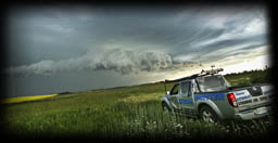
Non Severe Warned Storm that produced better structure than I was anticipating! We were actually out filming my Paranormal Investigation TV Show Knights Of The Dark which airs Friday nights on Access7 Cable TV - and why the Access7 vehicle is in some of the shots. It was fun to take my Paranormal Co-Star on his 1st storm chase :)
A few PHOTOS of the day:
Photo 1 |
Photo 2 |
Photo 3 |
Photo 4 |
Photo 5 |
Photo 6 |
Photo 7 |
Photo 8 |

just a reminder that anyone can watch my Live Stream through ...
Severe Studios.com
Direct stream (full page) - LINK
WATCH on your Mobile Devices with these Apps (on Andriod & Itunes and are FREE):
MYRADAR Weather Radar:
Android |
iTunes

