
2020 CHASE DIARY


* When I am out Live Streaming, it will Broadcast live directly to the site & both my Twitter and my Facebook page.
* All my Videos can be found on my YOU TUBE channel.
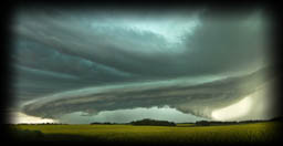
Thurs. Aug 27
Tornado Warned Storm over Yorkton SK
What started out as an INSANE sunset merging with a storm, quickly became a fast moving, hail dropping, Tornado Warned beast!
A few PHOTOS of the day:
Photo 1 |
Photo 2 |
Photo 3 (4 Photo Panoramic)
Tues. Aug 25
Tornado Warned Storm between Rhein SK - Roblin MB
The storm began with a big monster Wall Cloud and Funnel Cloud forming East of Rhein SK
Interesting chase day and this was by far the latest I have ever chased in any storm season ever before! It was fun to chase this from birth to death.
Models were suggesting 2 options - Yorkton SK to Roblin MB or Whitewood Sk to Virden MB.
I went with my gut and stayed close to home - glad that I did!
Seen and reported multiple funnel clouds and a couple wall clouds!
A few PHOTOS of the day:
Photo 1 |
Photo 2 |
Photo 3 |
Photo 4 |
Photo 5
FACEBOOK LIVE STREAM BROADCAST
HIGHLIGHT VIDEO - IN THE WORKS
Sun. July 12
Tornado Warned Storm between Yorkton - Melville SK.
The models for the day were showing the most potential was South of Regina (Weyburn to Estevan). I was seeing decent potential a little later between Fort Qu'Appelle and Yorkton.
I am glad I went with my gut this time and stayed put because WOW did it pay off !!!!
What a stunning storm!!!
Some of the nicest structure I have ever seen!
Shortly after the beautiful structure, I was in the rotation recording over 105 km winds !
Fantastic short chase day!
A few PHOTOS of the day:
Photo 1 |
Photo 2 |
Photo 3 |
Photo 4 |
Photo 5 |
Photo 6 |
Photo 7 |
Photo 8 |
Photo 9
HIGHLIGHT VIDEO
Tues. July 7
Severe Warned Storm between Eastend - Lafleche SK
Chasing a Squall Line East of Consul!
This day was a little tough to forecast and became a little frustrating.
Via models, I was seeing storms form at the Alberta border as well as Montana and push their way into the extreme SW corner of SK. That is what happened, but it did become a Squall Line mess (over 600 km in length) rather fast and eventually sped up and overtook most of the chasers, leaving them in the rain for hours!
Myself included. I was in the rain until almost Fort Qu'Appelle!
At one point, I was in a rain free area at Shaunavon while trying to decide 2 options:
1) go South towards the new storms coming in from Montana
2) push North to Gull Lake and then to Swift Current to "try" to stay in front of the Squall Line.
I procrastinated for too long and the fast moving storm over took me.
I should of went to Swift Current as my Brother working there began to send me photos of the beast moving in, and they were both intense & beautiful!
Not a fantastic chase day, but it had it's fun moments!
A few PHOTOS of the day:
Photo 1 |
Photo 2 |
Photo 3 |
Photo 4
HIGHLIGHT VIDEO - IN THE WORKS
Sat. July 4
Tornado Warned Storm between Crestwynd - Glasnevin SK
I was late to "the game" as I couldn't get going on the hwy until roughly 3pm, and as my initial target was Assiniboia, that's almost a 4 hour drive. Instead I choose Moose Jaw and then South as I knew the storms will already be in progress, that way I can just make my way to them.
I caught a Tornado (off in the distance, but still counts haha) before heading South to Crane Valley.
There were at least 3 Tornadoes on this storm, perhaps even 5-6. The action began around 4:30 , in which I was still over an hour and a bit away. So my goal was to catch up and make the best out of my own day - which is what i did :)
Started with Core Punching the storm around Crane Valley in which I got some impressive scenery!
From there chased the storm to Glasnevin area where everything then began to fall apart.
Later into the night,I then killed some time as the storm in Montana was finally crossing into Sk around Coronach. I got a couple shots of the Shelf Cloud, was cool but wasn't great so decided it call it a day and head home.
A few PHOTOS of the day:
Photo 1 |
Photo 2 |
Photo 3 |
Photo 4
HIGHLIGHT VIDEO - IN THE WORKS
Sun. June 28
Severe Warned Storms between Redvers SK - Boissevain MB
Yet another underwhelming chase day #2020 lol
I will call the day ... a wet frustrating mess!
Originally, via models I was seeing a couple different plays = Redvers SK to Pipestone MB, Carduff SK to Melita MB and ride the SK/MB border. In a way the storms did happen that way, but with all the cloud coverage and no day time heating, the storms just didn't perform!
I started off with what looked like a nice forming Shelf Cloud near Reston MB and then fell apart and that was pretty much the beginning of the end lol
Brandon MB got hit with flash floods and a brief Tornado did touchdown around Rapid City MB.
I spent most of the day trying to find just a little bit of storm structure, avoiding the horrible pot holes on MB roads (lol, but not lol) and then finding gas and one was "out of service" and the other coop card lock was "shut off" or something dumb!
But anyways ..... #2020
A few PHOTOS of the day:
Photo 1
HIGHLIGHT VIDEO - IN THE WORKS
Wed. Jume 24
Severe Warned Storms between Indian Head - Yorkton SK
Yet another underwhelming chase day #2020 lol
It was "ok" but definitely underperformed!
The chase day was very similar to my June 14 storm where I went to Vibank, caught a fast system and then nothing until heading home around Melville.
This time, I started in Indian Head, played catch up until around Grenfell where I blasted North to catch back up to the storm that was now around Duff. From there. followed it to Willowbrook and then to Yorkton where it all fell apart.
A few PHOTOS of the day:
Photo 1 |
Photo 2 |
Photo 3
HIGHLIGHT VIDEO - IN THE WORKS
Sun. June 14
Storms around Vibank and then later between Duff - Yorkton Sk
Very cool and interesting AND frustrating chase day! To me, the weather models looked weaker as the time came closer to the chase day and was getting a little nervous about another bust!
Started the day around Vibank where we stayed in front of a very fast moving cell that other chasers fallen behind on near or around Weyburn and South.
We caught a beautiful Shelf Cloud forming on the cell and decided to play with it as we knew we were going to not be able to catch up, so decided to just enjoy it!
We did fall behind and never could catch up.
Upon heading home, caught a new storm around Duff and chased it to Yorkton.
This cell, was absolutely fantastic and I was shocked that a tiny cell could be so intense and beautiful !!!
A few PHOTOS of the day:
Photo 1 (Vibank) |
Photo 2 |
Photo 3 |
Photo 4 (Melville) |
Photo 5
Photo 6 |
Photo 7 |
Photo 8 |
Photo 9 |
Photo 10 |
Photo 11 |
Photo 12
HIGHLIGHT VIDEO
Tues. May 26
Storm between Willowbrook - Yorkton Sk
Nice little Thunderstorm to start off the season for me and get that "practice run" in and over and done with!
The rainbow at the end of the day was magnificent!!!
The best part was, I got to take my super sexy fiancee on her first ever storm chase :)
A few PHOTOS of the day:
Photo 1 |
Photo 2 |
Photo 3 |
Photo 4

just a reminder that anyone can watch my Live Stream through ...
Severe Studios.com
Direct stream (full page) - LINK
WATCH on your Mobile Devices with these Apps (on Andriod & Itunes and are FREE):
MYRADAR Weather Radar:
Android |
iTunes