
2021 CHASE DIARY


* When I am out Live Streaming, it will Broadcast live directly to the site & both my Twitter and my Facebook page.
* All my Videos can be found on my YOU TUBE channel.
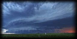
Tues. Aug 31
Severe Warned Storm between Strasbourg - Lumsden SK
For me, this day was all a challenge! I worked until the early afternoon and then headed West! Days that I work, I sometimes find a challenge as I can't sit down and work on my forecasting as precise as I like to.
For a target, I seen 3 options - North of Regina, Moose Jaw area and South of Regina.
I chose North of Regina and headed towards Southey area.
Storms were firing up nicely and around Earl Gray, got some pretty structure forming.
Decided to get ready for the live stream! I had my car as the truck is already "put away" for winter mode. I quickly installed the RAM Laptop mount, only to find out and remember that I didn't change the holding claps as I got a new laptop, so there was no way it was going to hold - so no live stream!
That's fine, and away I went!
I caught up to the North moving storm at Strasbourg, where it looked better on radar than what it was visually (which has happened to me a few times this 2021 season).
Shortly after, it got weaker.
There was a beautiful system forming on radar near Eyebrow and was heading not far from me, so away I went once again.
I made my way to Duval and the West on a grid road to make my way to Liberty.
That was the end for me!
Unfortunately, I forgot about one thing - Last Mountain Lake. The road leads up to the lake, dead end (and is an over 1 hour detour to get to Liberty), so Game Over for that storm!
I sat frustrated for a bit trying to decide what to do next and possibly salvage the day so it wasn't a total bust!
While this was happening, my chaser friends were on a storm cell that formed South of Moose Jaw that at this moment was just showing stunning storm structure around Rouleau and coming Regina inbound!
I decided to backtrack and head towards it, but because it has been dropping a TON of hail, was trying to do so safely as my car does not have hail armor like my truck does!
I made my way down to Lumsden and then pulled into Seven Bridges Road to capture a beast heading right over me!
It was beautiful, but was moving so fast, and had so much rain coming with it, only had a couple mins to take photos.
From there I backtracked to Dysart and then South to Fort Qu'Appelle to get in front of the big storm system.
It worked, but I lost all daylight hours and the structure was then gone.
From there I headed home with the storm, stopping every now and then to catch some lightning shots!
It is rare that I feel upset when I miss a storm moment from my forecasting, and this unfortunately was one of those days!
I did salvage it somewhat, but sure would of liked to of been around Rouleau once I seen the reports of the beautiful structure showing up on social media!
A few PHOTOS of the day:
Photo 1 |
Photo 2 |
Photo 3 |
Photo 4 |
Photo 5 |
Photo 6 |
HIGHLIGHT VIDEO
Thurs. July 22
Severe Warned Storm near Weyburn SK
Yet another frustrating chase day that began with many models disagreeing with one another!
Finally picked a target (near Fort Qu'Appelle) and sat, waiting .... and waiting .... and waiting!
Originally, models were suggesting to me that the storms "could" fire up anytime after 3pm or so. They were going to be in my region and blow East to the MB border.
The Boundary was there, even had a straight row of clouds forming on it for a long period of time, but ... nothing was happening.
Meanwhile, a couple cells were popping up near Assiniboia.
There were quite a few chasers in and around the same area as me, and via Spotter Network could see, that much like myself, they were all standing their ground, not flying South to the Assiniboia storm.
After about 1.5 hrs or so, we said screw it .... and dropped South!
Glad we did!
Caught a beautiful storm just to the North of Weyburn!
From there we watched it till it's death - which was really weird as it gave off some bizarre circle like structure!
Caught some lightning and then headed home!
As we were heading home going North East, the later system (10pm) was now in full swing and was heading towards Yorkton, so we pulled over again to get some lightning shot from that while on route home.
A frustrating day turned into a beautiful day!
A few PHOTOS of the day:
Photo 1 |
Photo 2 |
Photo 3 |
Photo 4
Sun. July 11
Severe Warned Storm Craven - Southey SK
It was a long and fairly stressful day!
Most of the day was waiting for the storms to form around Moose Jaw in +35 c weather!!!
That alone is frustrating lol
Forming storm after forming storm all moving insane fast. Too fast that none had time to feed and grow into anything and would all just die off.
I knew that all the stuff in the SW was going to be a later game so backtracked back to Craven where the storms looked just as bad lol.
At this point said screw it and gave up.
Went for supper.
On the way home seen an isolated storm moving East from around Central Butte but didn't pay much attention to it as it was a ways away.
Decided to follow the storm around Cupar but then turned around and waited for the isolated cell coming in from the West as it was moving and FAST!
Around 9pm got a beautiful cell around Southey for about 17 mins.
It was moving soooo fast. Took my pics and video and away I went as the structure fell apart and began to over take me.
From there played the game of Cat & Mouse (stay away from the storm, grab a few shots and then drive some more).
Along the way home, caught a few lightning photos.
A frustrating day turned into a beautiful day!
A few PHOTOS of the day:
Photo 1 |
Photo 2 |
Photo 3 |
Photo 4 |
Photo 5 |
Photo 6
HIGHLIGHT VIDEO
Wed. July 7
Tornado Warned Storm just West of Caronport SK
What beautiful storm structure to end a fantastic day!
This day, was more planned out to be a day of exploring Saskatchewan, the storm chase at the end of the day was just an added bonus !!!
With storms being beyond quiet this storm season, good chaser friend, Craig Boehm aka Skstormchaser Photography by Craig Boehm gave me some great tips on a few spots to go check out, and away I went!
Started out with a couple old but photogenic bridges before Craven, followed by a beautiful little church and then the Last Mountain House Provincial Historic Park.
After all of that, headed to the Lumsden area where we got photos of an old stone house, took the scenic drive on the "Seven Bridges Road," took some shots of the river bend and ended the drive at Cottonwood School!
After ALL of that, seen the storms forming to the West of us on radar (roughly an hour away), so away we went to go storm chasing!
Spent 14 hours on the road, fantastic adventure day!
Follow Craig's adventures here:
SK STORMCHASER PHOTOGRAPHY
A few PHOTOS of the day:
Photo 1 |
Photo 2 |
Photo 3 |
Photo 4
HIGHLIGHT VIDEO
Sat. July 3
Rhein - Wroxton SK
Nice little storm cell came though. Looked nice on radar but visually was on the weak side! (The storms were lacking the correct ingredients to grow and strengthen)
Glad to FINALLY see a storm in 2021 though!!!
Only took over 2500 photos to catch this ONE bolt haha!!
Models were suggesting 2 areas that drew interest to me. One being Estevan to Oxbow and the second being the Yorkton area. (Yorkton to Canora).
The cap was looking really strong for everything so I was not expecting too much or anything to happen around Oxbow (and nothing did) but was hoping the stuff around Yorkton, even if just "Popcorn Convection" would be good enough to get me out of the house haha!
A few PHOTOS of the day:
Photo 1 |
Photo 2 |
Photo 3 |
Thurs. June 10
Yorkton - Assiniboia SK
Bust day
Drove for 13 hrs and 980 km's
Started in Yorkton SK, drove to Assiniboia to wait for the storms. From there headed to Rockglen to wait for the storms to come across from the States, where storms began to form around Assiniboia.
Said screw it and went for the storms that were to my East (at the time around Big Beaver) and followed it all the way to Estevan.... Looked good on radar.... Literally ZERO structure!!!
Took a photo of some baby Mammatus Clouds and then went back home to Yorkton!
But.... That's what storm chasing is all about! Taking a risk or missing something that might form.
Today, nobody won. All storms were weaker then the models suggested, BUT it was awesome getting to run into a couple chaser friends I probably have not seen for a year or even 2!!!
A PHOTOS of the day:
Photo 1
Fri. May 21
Freak Ice Storm - Yorkton SK Parkland Region
On this thay there was a freak Freezing Rain storm that caused chaos in in Yorkton, Melville and surrounding communities!
Trees were down everywhere from the weight and taking down many, many powerlines with them! Some areas had no power for 8 hours to 3 days!
A few PHOTOS of the day:
Photo Set

just a reminder that anyone can watch my Live Stream through ...
Severe Studios.com
Direct stream (full page) - LINK
WATCH on your Mobile Devices with these Apps (on Andriod & Itunes and are FREE):
MYRADAR Weather Radar:
Android |
iTunes