
2022 CHASE DIARY


* When I am out Live Streaming, it will Broadcast live directly to the site & both my Twitter and my Facebook page.
* All my Videos can be found on my YOU TUBE channel.
Sat. Aug 13
Severe Warned Storms around the Yorkton SK Canada area
There was potential in few different places on this day. Models were disagreeing and so was I (haha)! I ended up sitting the day out, hoping to catch some storm action sometime after sunset.
That is exactly how it worked out!
Started as a storm came from the South moving North East towards Yorkton/Willowbrook area. Caught some cool structure and then blasted to the next storm passing Foam Last moving East.
This storm was active for a few hours already as it began West of Saskatoon.
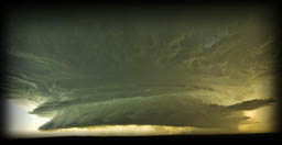
I headed towards Theodore, found a spot and snapped a few cool shots of the night time Shelf Cloud as it past over very quickly!
Decent local short chase day!
A few PHOTOS of the day:
Photo 1 |
Photo 2 |
Photo 3 |
Photo 4
? CHASE VIDEO COMING SOON ?
Sat. July 30
Tornado Warned Storm just North of Wroxton SK Canada
Photo taken by my Mom !
There was potential for severe weather in a few different areas on this day. I didn’t see much that looked great as it looked like it was all going to be fast moving messes, and it was!
Storms happened as models showed. Storm cells from Regina area all the way South into USA. Another system formed and become Tornado warned between Fenwood and Melville.
After that, around 7pm another system was blasting through Foam Lake. This one was sort of heading towards Yorkton.
That cell dropped a ton of rain and hail North of Yorkton, more around the Canora/Good Sprit areas and perhaps a little more North.
As it past through Yorkton (just rain), a cell in front of the system (to the East) became isolated between Wroxton and Kamsack.
I called my parents to see if they can safely check it out for me, and away they went!
At 8:01 pm, my mom took this photo. This is looking North towards Wroxton at the Tornado Warned storm!
It was moving so fast, within a min or two the structure was gone and away it went and it continued moving East (no longer with a warning on it)
PHOTO from the day:
Photo 1
Fri. July 22
Severe Warned Storm between Torquay - Beinfait SK Canada
This was defiantly a tough chase day!
Models were suggesting a variety of storms all over the place across the province.
The severe storms that I was searching for, were going to form South West of Weyburn anytime after 2-3pm and strengthen as they move East towards Estevan and then the MB Border.
There was also a chance of a strong CAP, High Based Storms and/or that the storms would mostly stay right along the Canada/USA border, and then stay USA side (which is mostly what happened).
I was stationed around Weyburn. Around 4:30 pm a storm finally began to form just South of Torquay (still on the Canadian side) and away I went!
I caught up to the storm around Hitchock at 5:20 pm as I then decided to Core Punch to get to the South Side of Estevan!
I got through, and for a brief period had some cool storm structure as it kept flying SE.
I kept pushing East, where just outside of Estevan, had a good blast of hail and a lot of rain. I followed it to Beinfait where I finally decided to call it a day as it was heading states side, putting on a MUCH better show for them!
Shortly after my storm by Estevan, the storm did it’s right hand turn and began to enter USA , putting on an AMAZING show with INSANE storm structure that began to take shape just south of Sherwood North Dakota!
By Glenberg ND (North of Minot), it was an absolute BEAST of a Tornado Warned storm !!! Possibly, the Storm Structure of the Year!
On the way home, I caught a stunning sunset at Kenosee Lake.
THIS .... was the absolute MONSTER that stemmed from the storm that I was on near Estevan SK before it moved into the states !!!
This was a few hours later (8:52pm) near Glenburn, North Dakota! (just North of Minot)
A few PHOTOS of the day:
Photo 1 |
Photo 2
? CHASE VIDEO COMING SOON ?
Sun. July 17
Tornado Warned Storm between Liberty - Tuxford SK Canada
This day’s forecasting was a challenge! I was seeing a couple different options. One being Weyburn and South (which ended up having a nice storm and dropped a Tornado) and another setup around Raymore. I chose Raymore region and away I went.
Sat in crazy muggy 30+ Degree heat while waiting, and waiting and waiting.
Boundaries forming all over, including my spot! Line of clouds would form and then die off. Form and then die off, over and over again.
Nothing was happening.
The Storms South of Weyburn began to fire up. My side .... still nothing.
Finally, around 5 pm North of Lucky Lake (to my West) a storm began to form on Radar. I waiting to see what direction it was taking and also was cautious of “jumping the gun” aka heading to the storm and missing a storm at my spot.
I let it run a few radar scans and then away I went!
Around 6:30 pm it was looking insane on radar as I was right around Liberty trying to get more South as it was moving straight East at me, and it sucks trying to get storm photos when you are cored in hail and rain and can’t see anything haha.
7 pm, I was heading towards Craik as photos on twitter began to pop up of the beautiful storm structure happening between Grainland, Central Butte &Tugaske (also showing rotation on radar).
7:15 pm I was still working my way South while also trying NOT to get cored in this system as I made my way towards Chamberlain.
7:37 pm I was near North Grove looking West at some INSANE storm structure !!!!
After enjoying that for some time, blasted further South to not get stuck within the core.
I headed towards Tuxford where around 8 pm I found myself in front on an angry lowering with my anemometer clocking wind speeds from 110 - 121 km !!!!
From there, I was too far back to ever catch up to the storm that now is just moving, so sat back and watched the beautiful system from the back end as it made it’s way East towards Manitoba.
What a hell of a beautiful chase day!!!
A few PHOTOS of the day: (MORE TO COME SOON)
Photo 1 |
Photo 2 (WOW!) |
Photo 3 |
Photo 4
? CHASE VIDEO COMING SOON ?
Fri. July 15
Tornado Warned Storm between Wynyard - Edgeley SK Canada
YOWIE WOWIE !!!! WHAT CHASE DAY !!!
This day’s forecasting was a challenge! It was one of those day that from the night before to the next am, everything shifted and then shifted again and again.
Originally, my target was around Raymore or Southey. (And I was watching for the models to shift to the North West like it has been in the past so in my mind, Foam Lake haha).
I was also seeing the days events happen in 2 phases. One earlier on in the day (1-3pm) and the next weather event starting between 4-6 pm. The storms did sort of follow this, but earlier.
The first system began forming around 11:15 am as it went through Allen Sk and dropped a Landspout Tornado. At the point, I was in my vehicle and heading towards Foam Lake to start the chase day!
I had my live stream fired up just East of Wynyard at 2pm to officially start my chase day.
Around 3:41 pm, I was South of Jansen on a storm with a nice base. I followed it till it’s death around 5pm when I then headed towards Lockwood.
From there, I could see the base of the storm to my South West and it was looking nice, even from afar! I blasted South to keep out of it’s direct path and to stay dry. I also forgot at that moment that between myself and the storm (was around Imperial), was Last Mountain Lake.
That prevented my plan of getting to the South side of it, so I did the next best thing and blasted South of Govan and went West on a grid road. Around 6:15pm I had some absolutely incredible storm structure !!!
It actually kept getting better, and better and better!
After watching that storm for quite a while, I picked my jaw up off the ground and dropped South towards Strasbourg. Things got a little intense while driving as on the way there, I was near some rotation to my West.
Once I get to Strasbourg, it got a little intense yet again as the entire sky was rotating and for a moment I had a sick feeling that the town was about to get struck by a Tornado!
Luckily, that did not happen!
From there, I headed towards Fairy Hill and seen yet again, some insane sky structure!
The day just didn’t want to end, haha!!!
After that, I headed towards Piapot where I got near some rotation yet again. While that was happening, just East of me at Edenwold, there was a funnel cloud reported by another chaser.
The storm had a dangerous core in it and was moving the exact same direction as me so I decided to let it go. I slowly made my way to Edenwold and there, as the storm was now East of me, I witnessed some of the most beautiful Mammatus Clouds I’ve ever seen to date!
I watched them for a bit, and then that’s when the insane lighting show began.
What a hell of a beautiful chase day!!!
A few PHOTOS of the day:
Photo 1 |
Photo 2 |
Photo 3 |
Photo 4 (What A Storm) |
Photo 5 |
Photo 6 |
Photo 7 |
Photo 8 |
Photo 9
Photo 10 |
Photo 11 |
Photo 12 |
CHASE VIDEO
Sun. July 10
Severe Warned Storm between Dysart - Melville SK
This day’s forecast was a challenge for me! To begin with, I was seeing it as a “Wet Mess Day” with possible targets all over the place lol.
I was also keeping in mind that I have been noticing a pattern with Nam3k models, which have been fantastic, but what they show vs what happens is that what happens is North West of the target - 3 chases in a row, so I took that into account today.
I was originally looking at Fort QuApelle/Indian Head and down the #1 hwy East. So I sat at the Fort waiting, hoping my pattern was right, thinking it would be North West instead.
Storm began to form around Cupar (to the North West of where I was), and away I went!
Caught up to the supercell around Dysart and boy was it beefy off the bat! Seen 2 or 3 Wall Clouds and a couple funnels fairly fast!
From there, I played the game of cat and mouse. That means I would drive to the East to stay out of the rain and then pull over facing the storm to the West (behind me) every now and then to watch as it continues to push East.
It fell apart a good 2 or 3 times, but also kept trying to form into more than it was.
To the West of Melville it began to do just that, once again as I got some more structure out of it before everything was overtaken by the rain and it turned into that “Wet Mess.”
A few PHOTOS of the day:
Photo 1 |
Photo 2 |
Photo 3 |
Photo 4
? CHASE VIDEO COMING SOON?
Sat. July 9
Severe/Tornado Warned Storm between Foam Lake -Invermay SK
This day was once again, one of those days where weather models kept wanting to mess around with our minds haha (kept changing). My original Target was between Southey - Raymore, but that never happened and it showed as the models progressed throughout the day!
Storms began to fire off around 4:30pm just North of Leroy and away I went!
My plan was to head to Foam Lake and then blast North to catch the storm as it passes by, and that plan worked great!
North of Foam Lake at Fishing Lake, I had a beautiful scenic lowering wall cloud develop. I observed that for some time and then kept pushing East to stay with the system.
I stayed on the storm on a decent grid road that took me North of Margo and Invermay where I stayed with the storm until it’s death!
At one point roughly North of Invermay, things began to ramp up rather nice with some angry storm structure but everything capped off and died shortly after!
On the drive back home, ended up seeing a fairly rare phenomenon called Anticrepuscular Rays!
A few PHOTOS of the day:
Photo Set 1 |
Photo Set 2
CHASE VIDEO
Thurs. June 23
Severe/Tornado Warned Storm between Yorkton - Dubuc SK
The models for this day was suggesting a variety of storm options all over the province, and some could become tornadic! Swift Current, Saskatoon, PA, Moose Jaw, Estevan and Yorkton area.
I had to work super early in the am so I went with the local chase (Yorkton area).
Storm did form all over the place! I stood my ground and when I pixel formed on radar in my area, I went for it (that being South of Melville)!
I caught a beautiful little cell at Killaly that was trying to become a stronger storm, but struggled at the start.
I stayed with it as I pushed East to Grayson and then to Dubuc. It would weaken and the strengthen up, weaken and then strengthen up. Ended up having 1 or 2 wall clouds on the system.
At this point, it was shortly after 7pm and I knew I had to be up at 2am for work, so made a quick decision that it won’t do much more (perhaps tried to convince myself to leave, haha).
Anyways, I did! As it reached areas like Esterhazy, it grew into absolutely fantastic storm structure!
At that point, I was already heading back, hoping to play with the storm that was near Otthon.
I caught up to that storm and had a possible lowering right off the bat! I stayed with it until just a couple miles South of Yorkton on hwy 9 where I caught some brilliant structure!
That structure .... brought the hail !!!
Yorkton got beat up pretty bad with this hail storm and it kept moving East and I headed home.
The largest hail stone I seen was Golf Ball sized.
With the hail and the 1.5 inches of rain, in a very short time - they city streets were flooded!
As I made my way home, a 3rd system was now on it’s way to Yorkton but I really needed some sleep (after 10 pm). This storm had some incredible structure in it !!!
Hell of a chase day!
A few PHOTOS of the day:
Photo 1 |
Photo 2 |
Photo 3 |
Photo 4 |
Photo 5 |
Photo 6 |
Photo 7 |
Photo 8 |
Photo 9 |
Photo 10
HIGHLIGHT VIDEO
Sun. June 19
Severe Warned Storm between Wroxton SK - Roblin MB
This day, was a challenge.
Reading models was tough as I was seeing targets all over the place! Assiniboia, Whitewood, Carlyle, Langenburg to Russel MB.
There was also a strong cap.
I decided to say screw it and stick to my gut instead of dropping to somewhere like Whitewood and then getting lost in a giant 70-80 km moving wet mess (which was what I was expecting).
3 pm came, most chasers were in the Weyburn - Estevan region on a big cell that was forming, and BOOM! One pixel formed between Calder SK & Roblin MB, so away I went!
Like my 1st chase, the storm looked better on radar.
I began with a pretty nice storm trying to Shelf out roughly 1 km West of Wroxton. Watched it for a bit as I had a couple of lowerings and then continued on to Roblin.
Roughly 3-5 kms West of Roblin, I was in some intense rain and had quarter sized hail.
From there played with the Whale’s Mouth as that storm blew past mega fast and became unchasable.
I headed back to Wroxton where another storm was forming, but died as quickly as it formed, so called it a day.
A few PHOTOS of the day:
Photo Set
HIGHLIGHT VIDEO
Sun. June 12
Severe Warned Storm between Ituna - Otthon SK
The day's weather models seemed to be battling each other haha!
Things were frustratingly disagreeing and changing on each run.
I wasn't even sure if I was even going out to chase, BUT if I did, my target area that I was watching was the Carlyle to Wawota SK area.
I procrastinated too long on if it was worth it or not (as it is about a 2 hr drive, and did not want to go for nothing), and by the time I decided on what to do, the storms were already taking bloom.
With that said, forming in much more than my targeted area. I seen a nice storm forming to the West of me that was going to be moving into the Ituna region and another one South of Melville. I chose Ituna and away I went!
Once I got to Ituna, blasted South and decided to Core Punch the cell to get to the South side of the storm to see what there was for structure.
While Core Punching, had over 70+ km winds read on my anemometer as well as got pelted with small hail for a short time.
Once I got past, sadly everything was too high based and outflow-dominant. The temps went from +24c before going through to +13 on the South side.
I observed for a bit to make sure it wasn't going to regrow in strength and then decided to "head home while chasing" so to speak haha.
I went through Balcarres and then back North through Melville where I got in line with some storms that were forming along that path.
They too were high based and like the storm I had before, looked much better on radar then in person.
I did manage to get a couple cool shots of some minor structure along the side of the storm before making my way back home.
Overall, fun 1st chase for 2022 and it was a good run to work out the kinks in my Live Stream! Had audio issues, but got them fixed while on this chase!
A few PHOTOS of the day:
Photo Set
HIGHLIGHT VIDEO

just a reminder that anyone can watch my Live Stream through ...
Severe Studios.com
Direct stream (full page) - LINK
WATCH on your Mobile Devices with these Apps (on Andriod & Itunes and are FREE):
MYRADAR Weather Radar:
Android |
iTunes